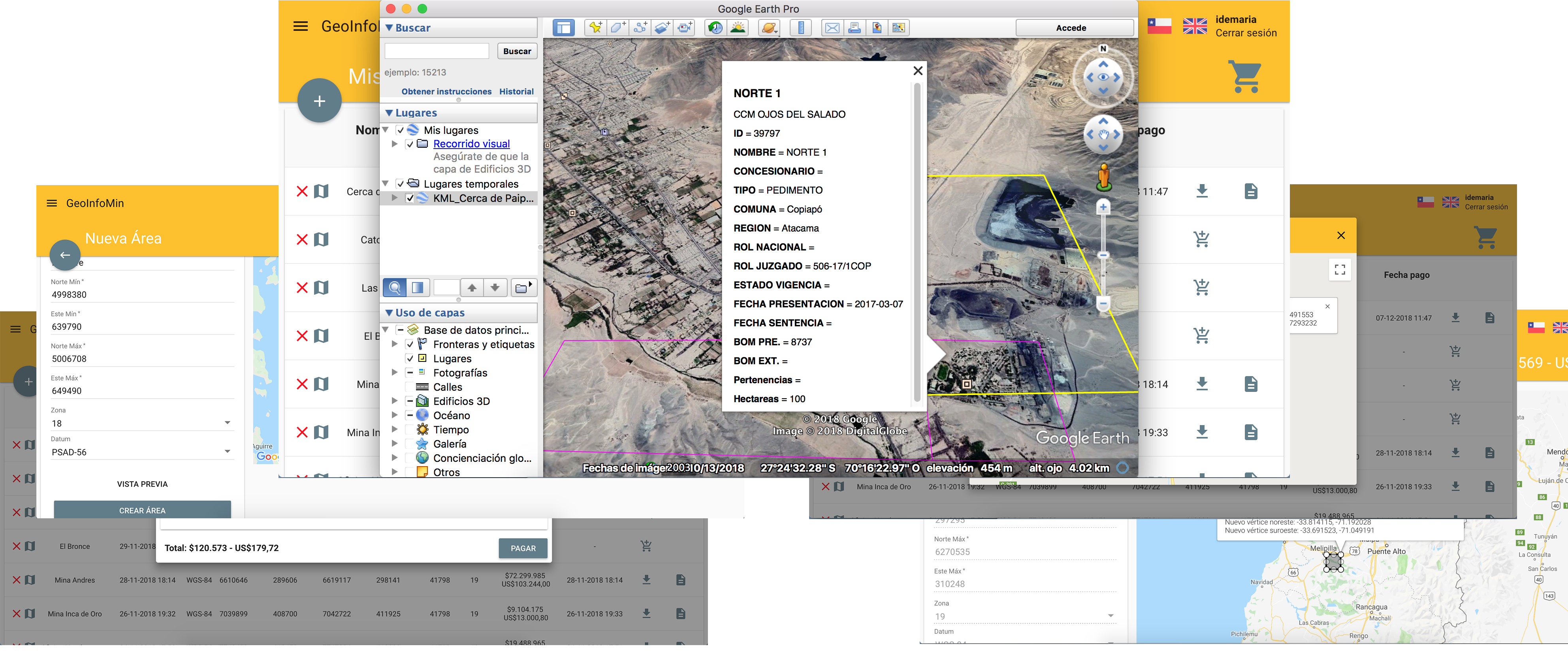
Message successfully sent to Geoinfomin.
Automated surveillance of your areas of interest and online alerts for new presentations (Mobile App and email).

Welcome to GEOINFOMIN

Chilean Mining
Cadastre Online

Scroll Down

About GeoInfoMin

GeoInfoMin provides online technological services that will allow you to obtain reliable and up-to-date information on mining concessions both in process and already established, to manage areas of interest and to monitor mining rights applications, in an environment of reliability and privacy of the information consulted.

APP Mobile

GeoInfoMin has a mobile application for Android and iOS platforms, which allow you to check the information of your contracted areas, as well as receive alerts from surveillance services.

Polygon Surveillance

GeoInfoMin provides a surveillance or monitoring service, which aims to alert changes or variations experienced by the mining rights contained in a given area.

Alerts

If there is any variation in one of your areas of interest, GeoInfoMin will send an alert to your mobile phone and an email with information on the areas that were affected.

Validity of information

The information contained in our reports is validated by a Geometry Engineer and Mining Measure Expert. The technological platform is powered by Tecnología Aplicada Limitada (TA), a company that has extensive experience in technological services in the mining and other industries.

Intuitive platform

Get your report instantly in our consultation platform. It is simple, intuitive and bilingual.

Up-to-date information

Mining rights information is updated today.

Graphic definition of geographic areas

Define your area of interest in our graphic interface quickly, easily and simply.

Report in vector GIS format

The result of the report is delivered in the KML vector GIS format visible directly on the Google Earth © platform and in other geographic information systems (GIS) such as ArcGIS ©, MapInfo ©, Global Mapper ©, etc.

By provision of the Regulation of the Chilean Mining Code, mining rights must be georeferenced in Datum PSAD-56 or SAD-69, as appropriate. GeoInfoMin uses the parameters of the Chilean Military Geographical Institute to carry out the transformation to Datum WGS-84.

Content of the report

Your report contains the information, according to the chosen filters, of;

  • Belongings constituted under the validity of the Code of 1932 and Salitrales Estacamentos
  • Established belongings
  • Measurement requests
  • Manifestations
  • Exploration Concessions
  • Pediments

Publication of Prospect Notices

GeoInfoMin provides its subscribers with a section for the publication of notices of mining prospects in Chile, in it you can publish your notices for free, in a safe environment and maintaining private communication with those interested.

How does GeoInfoMin work?

Sign up

Create a free account in our service, enter the user data and you will be able to create your areas, it is not necessary to enter a credit card, consider that GeoInfoMin does not know or store data on payment methods.

Create an Area

Create an area to check mining concessions in Chile, you can create areas of up to 25x25 kilometers (625 km2).

Make the Payment

Pay in PayPal © or Transbank © the value of the selected area, the credit card details are recorded directly in the sites of the means of payment.

Download your Report

Download the KML extension file. KML is the acronym of the English "Markup Language Keyhold". This file must be opened in the Google Earth © platform, which interprets the file and displays in graphic form the mining properties in the area of interest and the relevant information contained therein.

App Screenshots

Price

GeoInfoMin allows you to consult the Chilean mining catastrophe by areas of up to 625 km2, consulting our database that contains the historical information of the publications of the Official Mining Bulletins and conservatory records from 1983 to date.
The query is generated in a KML format interpreted by the Google Earth platform, delivering information quickly, easily and intuitively.


Price From

US$83

value includes tax (IVA)

For an area of 100 km2.

  • Belongings constituted under the validity of the Code of 1932 and Salitrales Estacamentos
  • Established belongings
  • Measurement requests
  • Manifestations
  • Exploration Concessions
  • Pediments
Start Now

Soon the generation and storage of mining concession plans and other technological services linked to Chilean mining!

Subscribe our services, we will keep you informed of the news that we will be incorporating.